March 12,
2015 Doug Sims,
Chena River Slough Flood Hazard Mapping Project Status Update
Chena
River Slough Flood Hazard Mapping Project Status Update
Doug Sims,
Floodplain Administrator, Fairbanks North Star Borough
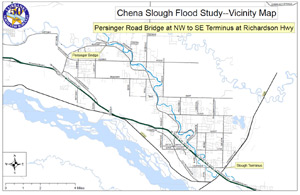 The
Chena Slough is a spring fed stream channel that has been cut off
from the Tanana River by the Richardson Highway and a series of
post WWII era Army Corps of Engineers levee projects designed to
reduce high water events in the City of Fairbanks. The slough is
a principal waterway located within the rural floodplain east of
Ft. Wainwright and west of the Moose Creek Flood Control Project.
The slough and its surrounding floodplain is heavily influenced
by groundwater and seasonal runoff. A new updated flood risk assessment
for the slough has recently been initiated by the Fairbanks North
Star Borough with grant funding from FEMA Region 10. The updated
study will build upon previous hydrology and hydraulic information
in conjunction with Lidar remote sensing in order to produce a more
accurate flood risk assessment for the slough.
The
Chena Slough is a spring fed stream channel that has been cut off
from the Tanana River by the Richardson Highway and a series of
post WWII era Army Corps of Engineers levee projects designed to
reduce high water events in the City of Fairbanks. The slough is
a principal waterway located within the rural floodplain east of
Ft. Wainwright and west of the Moose Creek Flood Control Project.
The slough and its surrounding floodplain is heavily influenced
by groundwater and seasonal runoff. A new updated flood risk assessment
for the slough has recently been initiated by the Fairbanks North
Star Borough with grant funding from FEMA Region 10. The updated
study will build upon previous hydrology and hydraulic information
in conjunction with Lidar remote sensing in order to produce a more
accurate flood risk assessment for the slough.